Places
Roški Slap: The Necklaces, the Watermills and Krka's Quieter Waterfall
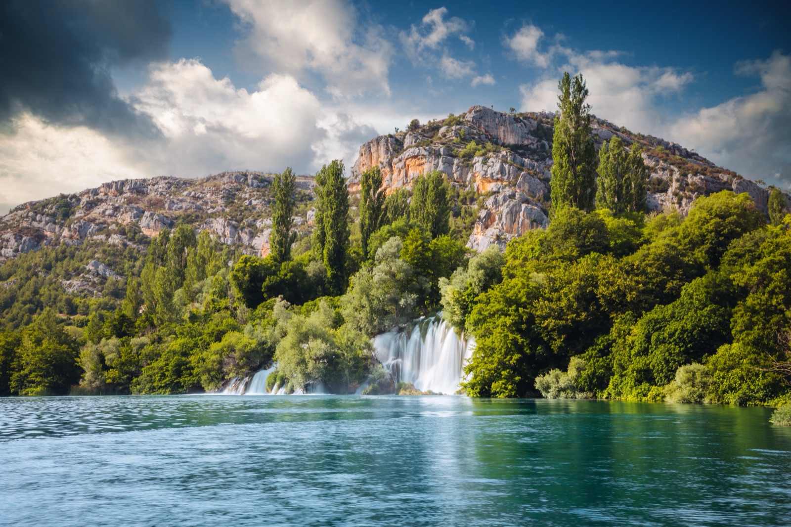
Roški slap is the second great waterfall of Krka National Park, 13 km upstream of Skradinski buk and about 36 km below the river’s spring. It is a wide, low barrier rather than a tall one: a run of small cascades that local people call the Necklaces, a maze of backwaters and tufa islets, and at the end a main fall that pours into Visovac Lake. Around it are a row of restored watermills, a road bridge that has crossed the river here since Roman times, and, at the top of the canyon wall, Oziđana pećina, a cave lived in from the Neolithic to the Bronze Age.
The park’s brochure calls Roški slap the second most visited waterfall on the Krka, and in practice it is the quieter of the two. You reach it by road via Drniš or Laškovica, by the free summer shuttle from the Laškovica car park, or on the park’s 4-hour boat excursion from Skradinski buk. This article covers what to see, the trails and steps, how to get there, the boats that leave from its docks, food, crowds and the best time to go.
Roški slap at a glance
- Where: the middle course of the Krka, between Visovac Lake below and the upper canyon above.
- What: a main fall the park gives as 22.5 m high, with countless backwaters, cascades and tufa islands above it.
- The walk: a 1,360 m circular trail across the Necklaces, completely flat.
- The climb: 517 wooden steps from the falls to Oziđana pećina.
- Getting there: by car, the summer shuttle from Laškovica, or by park boat from Skradinski buk.
- Tickets: the all-sites ticket, or a cheaper ticket for Roški slap and the upper-course sites only.
- Boats from here: to Visovac, and upstream towards the Trošenj and Nečven fortresses.
- Swimming: in the designated area only, from 1 June to 30 September.
Where it sits on the river
Roški slap is the sixth of the Krka’s seven waterfalls, 35.5 km from the source by the park’s measurement. Below it the river spreads into Visovac Lake, the calm stretch that holds the island monastery of Visovac. Above it the canyon narrows again. From the upper dock the park’s boats head upstream through the narrow Brzica straits towards Carigradska draga, where the Krka monastery stands.
The falls take their name from a castle. The park’s trail page says Roški slap is thought to be named after the medieval fort of Rogovo, or Rog, which stood on the right bank above the Među gredama canyon, the narrow strait that joins the falls to the lake. Nothing of the fort remains, but a trail leads to the spot. How the tufa barrier itself formed is the subject of our article on the Krka waterfalls.
The Necklaces, and how tall the falls are
The barrier opens with a series of small cascades, which the park’s trail page compares to lace across the chest of a bride from Bogatić, the village on the hill above. Behind them come backwaters and islets, and at the far end the main fall spreads like a fan into the lake.
How tall that fall is depends on which page of the park’s material you read:
- 22.5 m is the height of the main waterfall on the park’s page for Roški slap as a locality.
- 25.5 m is the height of the whole barrier, 650 m long, on its page for Roški slap as a waterfall.
- 15 metres is the drop into Visovac Lake in the brochure’s description and on the Laškovica – Žižići trail page.
They seem to measure different things: the height difference across the whole barrier, the main step, and the final drop into the lake. Whichever you use, Roški slap is broad rather than tall, and it is best seen from above.
The canyon around it is rich in life. The park’s trail page lists the endemic Croatian bellflower in the cracks of the cliffs, brown trout and chub in the river, and wildcats and otters among the rarer mammals.
Walking the Roški slap trail
The main walk is a 1,360 m circular trail over the Necklaces, and the park describes it as completely flat, which makes it one of the easiest walks in the park. It mixes gravel paths, a wooden bridge and a paved road bridge that carries all traffic except trucks over 7.5 t, so watch for cars on that section. The brochure’s suggested programme allows 3 hours for Roški slap as a whole, including the mills and a rest.
The trail also takes you over history. The park’s trail page describes a bridge of 22 stone arches across the river, left by the inhabitants of the Roman period. The road over the falls is one of only four crossings of the river, and it is not under the park’s control; because it is too narrow for a separate footpath, the park directs walkers onto its own bridge across the Necklaces.
The watermills
The left bank at Roški slap is lined with watermills, several restored and returned to their original use. The park dates the surviving mills to the 19th century and treats them as ethnographic monuments of rural architecture and the local economy.
The Laškovica – Žižići trail page tells their story. Six watermills worked at Roški slap until the 1960s. The ones nearest the water were the Friars’ Mills, which belonged to the monastery on Visovac; all four of them were reconstructed, and part of the millers’ building now holds a catering facility, a souvenir shop and a weaving workshop. Next to them, the ruined mill of the Šoster family of Miljevci was rebuilt to show how millers worked and lived.
What happens there today:
- Demonstrations of milling wheat and of washing and pounding cloth.
- An eco-workshop where children can take part with their parents.
- A souvenir shop selling local handmade products.
Oziđana pećina: the cave above the falls
High on the left bank, at the top of the canyon, is Oziđana pećina, the only cave in the park open to visitors. Excavations there found all the Neolithic cultures of the Adriatic region (Impresso, Danilo and Hvar) and Eneolithic cultures through to the Middle Bronze Age, with continuous human presence from 6000 to 1500 BC. An archaeological collection is displayed in the cave itself, in situ.
There are two ways up:
- From the falls: 517 wooden steps laid up the rock face, which the park’s trail page calls a highly strenuous ascent.
- From Bogatić Miljevački: park at the car park and walk a 500 m trail and 99 steps down to the cave. This is the easier way, and you can then continue down the 517 steps to the Necklaces.
Two practical points. The park’s cave page says Oziđana pećina is open from April to the end of September, while the brochure says April to October; in winter it opens by appointment only, so check before you go. And cards are not accepted at the cave, so carry some cash. The brochure allows an hour for the visit.
Other trails around Roški slap
Several of the park’s educational trails start at or lead to Roški slap. The park’s own advice is that the whole of the falls is best seen from two hills, one on each bank.
- Niz ploču, 1,500 m, left bank. From Bogatić Miljevački, flat to a viewpoint, then down cuts in the hillside and the rock face to the Necklaces, with a railing along the cliff. It needs good non-slip shoes and is recommended in dry weather only. The park credits the idea for the path to Jasna Skelin Duboković of Drniš, who grew up at Roški slap.
- Laškovica – Žižići – Roški slap, 3,300 m, right bank. From the Laškovica visitor centre or the car park by the Roški slap reception, gravel with one long climb, and the best view of the falls and of the hydroelectric plant.
- Rogovo, 2,300 m. Signed from the Rupe – Laškovica road; flat through woodland, then a narrow, steep earthen passage to a viewpoint over Među gredama, the strait used as a location for the Winnetou films.
- Stinice – Roški slap – Oziđana pećina, 8,500 m one way. The park’s long middle-course hike, from the oak forest at Stinice past the remains of the Kamičak fortress, across the falls and up to the cave, ending at Bogatić at 234 m above sea level. It has 200 steps in the wetland section, the 517 steps and another 99 above the cave, and is not circular; from June to September a bus links Laškovica, Roški slap, Bogatić Miljevački and Stinice.
The canyon cliffs are also home to twenty-two bird species, including the short-toed snake eagle, which nests here.
Getting there: Laškovica and the road in
Roški slap is reached by road from Drniš or Laškovica, on the Šibenik – Pakovo Selo or Šibenik – Skradin roads, or by the excursion boat from Skradinski buk. By the park’s distance tables it is 38 km from Šibenik, 42 km from Vodice, 76 km from Trogir, 81 km from Zadar and 105 km from Split. From the park’s own entrances it is 33 km from Lozovac and 17 km from Skradin, and the town of Drniš is 18 km away.
In summer you leave the car at Laškovica or at Bogatić Miljevački. Laškovica has a visitor centre, the starting point for cycling and hiking on the middle course, and an electric car charging station. From there the shuttle to Roški slap is free, and on the park’s published timetable it runs:
- Laškovica to Roški slap: every half hour from 12.00 to 19.30.
- Roški slap to Laškovica: every half hour from 12.15 to 19.45.
- Stinice to Roški slap: 13.00 and 16.00; back at 12.45 and 15.45.
- Bogatić: arranged as needed with the reception desk.
Timetables change from year to year, so check them before you go.
The price list includes this bus in the ticket from 1 June to 30 September. Laškovica is just 2 km from the falls, and the Laškovica – Žižići trail is the walking alternative. For cyclists, one of the park’s routes runs Laškovica – Roški slap – Oziđana pećina – Roški slap – Laškovica: 24.5 km with 625 m of ascent.
The hydroelectric plant
The plant on the right bank is part of the Krka’s industrial story, and the park’s pages do not agree on its date: 1909/1910 on the Laškovica – Žižići trail page, 1910 on the waterfall page, 1911 on the industrial heritage page. It was built for the coal mines at Siverić, which it supplied through a 28 km power line; the town of Drniš was connected in 1915, and until 1918 it was one of the ten largest power plants in Croatia. Its generators were replaced in 1996. The older and better-known plant at Skradinski buk, which lit Šibenik in 1895, is covered in our article on the Krka waterfalls.
Boats from Roški slap
Roški slap has two docks, and the boats from each go in opposite directions. Tickets for the entrance and the boats are both sold at the Roški slap reception, and the boats run daily from April to October.
- Lower dock, to Visovac: a 2-hour round trip through the Među gredama canyon, with half an hour on the island. Available until 15:00.
- Upper dock, towards Trošenj and Nečven: a 2-hour trip upstream to the two medieval fortresses, seen from the boat. Departures until 15:00; €15 for an adult on the 2026 price list.
Both are arranged by appointment rather than on a fixed timetable, and some of the boats on the Visovac route are the park’s electric catamarans. If you are coming the other way, the 4-hour excursion from Skradinski buk gives you 1.5 hours at Roški slap, and you must return on the same boat. Our guide to Krka boat trips has the full timetable rules and prices.
Food and facilities
Roški slap has several places to eat, and some of them have a story:
- Three restaurants are still owned by the millers’ families, according to the park.
- The park’s own buffet is at the falls.
- The mills include a catering facility in the old millers’ building.
The park notes that most hospitality in the park is privately owned or run on concession, so prices vary from place to place. There is also a souvenir shop. Swimming is permitted only in the designated area, from 1 June to 30 September, at your own risk and depending on the weather and water level; jumping off the falls or bridges is prohibited.
Roški slap or Skradinski buk?
Skradinski buk is the bigger spectacle and the busier one. The park now caps visitor numbers there at ten thousand at any one time, and its brochure says it is directing visitors upstream, to Roški slap and Oziđana pećina, to ease the pressure. For a visitor that means:
- Fewer people on the trail: Skradinski buk, not Roški slap, is the most visited site in the park.
- A cheaper ticket if you skip Skradinski buk: the ticket for Roški slap and the upper-course sites costs adults €7, €12 or €20 by season on the 2026 list, against €7, €20 or €40 for all sites.
- More to do in one place: the mills, the cave, the boats and a swim in summer.
If you want both, the all-sites ticket covers each land locality once on the same day. Our guide to Krka tickets, hours and trails sets out the prices and the rules.
When to go
Roški slap keeps the same hours as Skradinski buk: 8:00 to 20:00 in June, July and August and 9:00 to 16:00 from November to February, with the months in between set out in the tickets guide. What changes through the year is what else is running.
- June to September: the shuttle from Laškovica, the bus for the long trail and the swimming area are all in service, and the vegetation is at its fullest.
- April, May and October: the boats run and the ticket is cheaper; the cave is open, though the park’s two sources differ on October.
- November to March: no shuttle, boats only exceptionally in March or November if the weather allows, the cave by appointment only, but the most water. The park records the Krka’s highest levels in November and March and its lowest in August.
Check hours before you go, especially in spring and autumn.
A day built around Roški slap
- By car from the coast: Skradinski buk early, then drive the 33 km from Lozovac to Roški slap; walk the Necklaces, see the mills, and take the boat to Visovac before the last departure at 15:00.
- Roški slap on its own: park at Bogatić Miljevački, walk down to Oziđana pećina and the 517 steps to the falls, then the circuit and lunch by the mills. Allow for the climb back up, or ask at reception about the Bogatić transfer.
- By boat: the 4-hour excursion from Skradinski buk, with half an hour on Visovac and 1.5 hours at Roški slap.
The tours page lists the all-sites ticket and the tours to Krka.
Frequently asked questions
Is Roški slap worth visiting?
Yes, if you have time beyond Skradinski buk. It is quieter, has the restored watermills, the Oziđana pećina cave and the boats to Visovac and the fortresses, and a designated summer swimming area.
Can you swim at Roški slap?
Yes, in the designated area only, from 1 June to 30 September, at your own risk and depending on the weather and water level.
How do you get to Roški slap?
By road via Drniš or Laškovica, parking at Laškovica or Bogatić Miljevački in summer, or on the park’s 4-hour boat excursion from Skradinski buk. It is 33 km by road from the Lozovac entrance.
How many steps are there to Oziđana pećina?
517 wooden steps from the falls. From the car park at Bogatić Miljevački it is a 500 m trail and 99 steps.
Is Roški slap included in the Krka ticket?
Yes. The all-sites ticket covers Roški slap on the same day as Skradinski buk. A cheaper ticket covers Roški slap and the upper-course sites without Skradinski buk.